Thursday, December 6, 2012

New Zealand in 1.000,000 years


New Zealand as we know it today may no longer exist.  This is because of the movement of the tectonic plates that the country sits on.  In 1,000,000 years the southern Island will be split up because of the twisting movement along the Alpine border.  This border is a hot spot for seismic activity and there is evidence that says that along this fault in the last 240 million years there has been 480 kilometers movement, with approximately 33 millimeters a year.


new-zealand-plate-tectonics
plate movement

As of today New Zealand is a mid-latitudinal country and this is reflected in its climate.  It gets approximately 10 inches of rain a year and is very mountainous and volcanic area.  This is due to the Tectonic activity of the area between the Pacific and Australian plates.  The country is diverse in plant life and geography from its dense Forrest's, Mountains, Volcanoes, and its plain areas where most of the agriculture occurs.  In 1000 and 10,000 years there will probably not be a lot of change in the geography of the island.  Yes there will be erosion in areas and the mountains will erode down slightly but the real changes will occur over a 1,000,000 years.
everglades

Not only that but the movement of the Northern Island will be continue to move North with the  movement of the Australian plate. The Australian plate moves 5.6 cm a year and in 1,000,000 it will have moved 56 Kilometers.  This amount of movement will place the northern tip of the country at 34 degrees south although its not a lot it does put the country at a point where it will begin to move into a subtropic Climate zone. Changing the plant life and the ecosystems in the area.  To a wet land like state meaning that the annual rain fall will increase greatly in some of these areas.  The influx in the amount of precipitation every year will cause flooding of the rivers on the northern island.  The plant life will become more dense making the area into something similar to that of the Everglades.


 The northern Island will also be going under elevation changes because of its close proximity to the border of two main plates. The Pacific Plate sub-ducts underneath the Australian Plate. This will be due also to the new growth in volcanoes and volcanic activity in the area.  This is because of the ability of the magma to rise up where subductions zones are.  Underneath the land the magma will pool and cause bulges and eruptions bringing new mountain ranges and land to the area.  The magma's rising will cause land form in the same way that the Hawaiian Islands had been formed.  
File:Subduction.png
magama pooling


This is all Here Say though because there is no possible way to completely know for sure.  That be true doesn't automatically mean there is no reason why this all couldn't happen just based off of the facts we have available and the trends that we see.

Link to work cited because it won't let me put on page
 http://easybib.com/export/html


Works Cited
"Geological Map of New Zealand." Geological Map of New Zealand. N.p., n.d. Web. 06 Dec. 2012.
"Indo-Australian Plate." Wikipedia. Wikimedia Foundation, 12 Mar. 2012. Web. 06 Dec. 2012.
"New Zealand Latitude and Longitude Map." New Zealand Latitude and Longitude Map. N.p., n.d. Web. 06 Dec. 2012.
"New Zealand." New Zealand. N.p., n.d. Web. 06 Dec. 2012.
New Zealand Tectonics. Digital image. N.p., n.d. Web. 6 Dec. 2012.
"Subduction Zone." Wikipedia. Wikimedia Foundation, 12 Apr. 2012. Web. 06 Dec. 2012.
"The Tectonic Forces That Are Shredding New Zealand." - Environment. N.p., n.d. Web. 06 Dec. 2012.


Tuesday, November 13, 2012

Storms In New Zealand


New Zealand because of its location and topography experiences a wide rang of weather events, form the normal seasonal to the severe destructive forces of Tropical Storms.  On average Northern New Zealand is struck by one Cyclone a year.  Since the Islands are located in the Pacific Ocean located about 32 degrees south of the equator, the area has the possibility of being hit by these storms.  This is due to the fact that there is a stronger Coriolis effect on this area and the water temperatures are warmer because they are closer to the equator.

File:Wilma 26 jan.jpg
Cyclone Wilma 
 Two of the worst Cyclones in New Zealand are cyclones Wilma hitting in 20011 and Bola hitting in 1998.  Wilma hit the coast of the the Northern Island as a Category 4 Cyclone, having wind speeds of 186 mph.  The rainfall and storm surges on the island reached 50 year flood  proportions, causing 19 million dollars in damages.  Bola was a weaker categorical storm but caused large amount of damage because of the rainfall, which in one area was about 14 inches.  The large amounts of rain ended up causing 82 million dollars worth of damage.

New Zealand also experience a large number of Tornadoes a year.  This is because of New Zealand mountain ranges and its proximity to the ocean it has the two ingredients to cause severe thunderstorms.  As the moist air coming from the ocean up mountains causes these thunder storms.  When these are combined with a jet stream the tornadoes occur.  These tornadoes are usually narrow with short tracks, and scale from and F0-F2 on the Fujima scale; the worst one occurring in 1948 killing 3 and injuring 80.
Tornado on Northern Island


work cited link: http://easybib.com/cite/view
Works Cited
"Current Weather Situation Latest Forecast Cyclone Reports, and Hurricane,flood Images." : New Zealand's Hit by Tornado. N.p., n.d. Web. 13 Nov. 2012. <http://abobora-oca.blogspot.com/2011/05/new-zealands-hit-by-tornado.html>.
"Cyclone Bola." Wikipedia. Wikimedia Foundation, 11 Dec. 2012. Web. 13 Nov. 2012. <http://en.wikipedia.org/wiki/Cyclone_Bola>.
"Severe Tropical Cyclone Wilma (2011)." Wikipedia. Wikimedia Foundation, 07 Sept. 2012. Web. 13 Nov. 2012. <http://en.wikipedia.org/wiki/Severe_Tropical_Cyclone_Wilma_(2011)>.
"Tornadoes of Australia and New Zealand." For Strong Winds:. N.p., n.d. Web. 13 Nov. 2012. <http://www.islandnet.com/~see/weather/storm/tornadoes-aunzea.htm>.
Wilma. Digital image. Wikipedia. N.p., n.d. Web. <http://en.wikipedia.org/wiki/File:Wilma_26_jan.jpg>.

Thursday, October 11, 2012

Hydrology of New Zealand


Physical map of water ways 
New Zealand is covered in approximately 180000 kilometers of mapped rivers and 3820 lakes with a surface area of a Hectare or larger. The country also used to be covered in large sums of wetlands.  These are caused when the ground is over saturated with water causing the surplus of ground water to become visible on land. These wet lands though are endangered because of heavy draining for farming with only 2% of it being left. There are two large bodies of water that occur on the Islands there is Lake Taupo on the North Island, and Lake Te Anau on the southern.
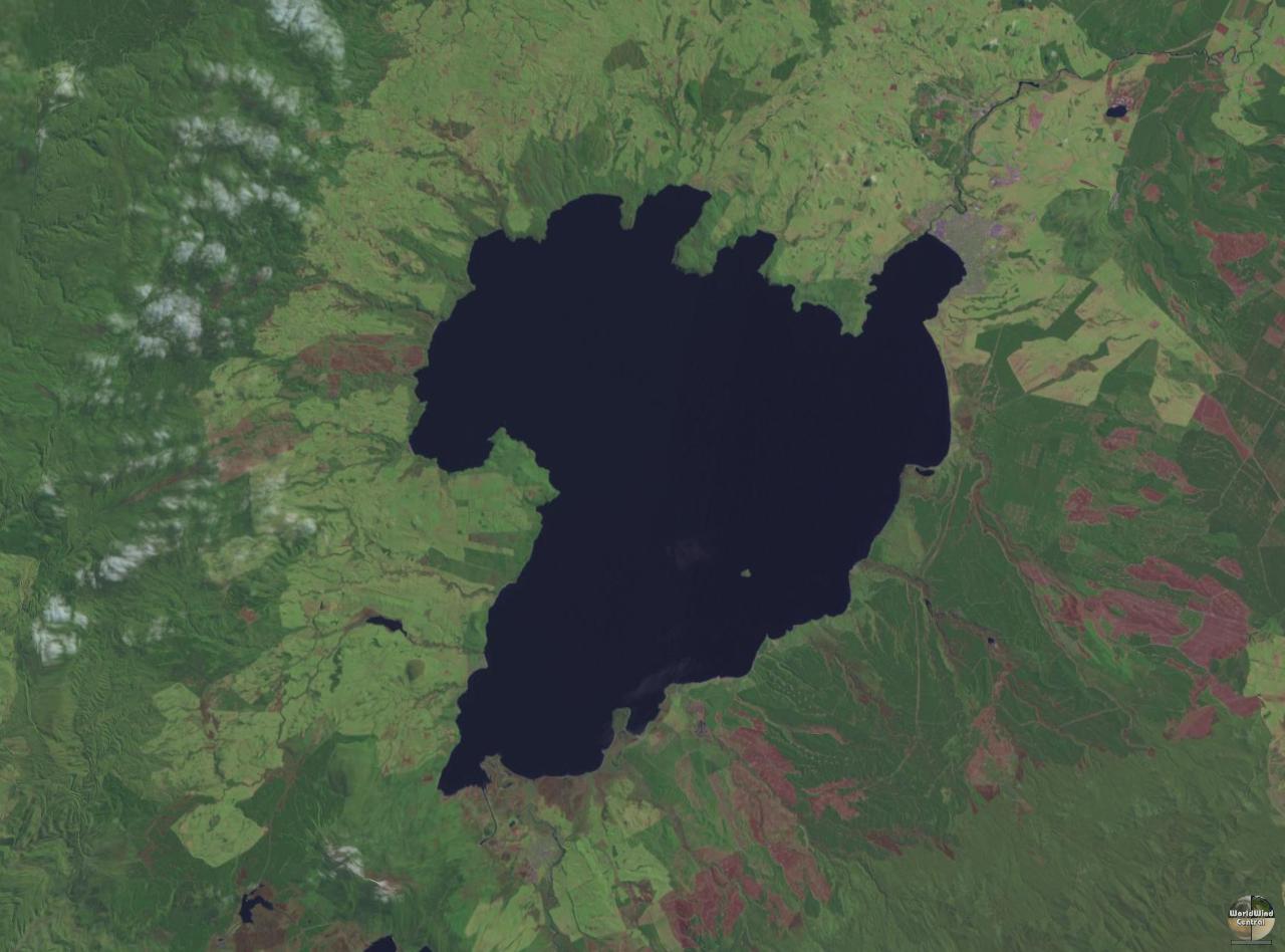
Lake Taupo

Lake Taupo is the largest lake in the entire country with a surface area of 616 square kilometers.  With the eruption of 186 A.D. and the   collapse of the Taupo caldera Lake Taupo was formed.  The formation and rapid filling plus the eruption of the super volcano the biggest Outwash flood occurred in the country's history. An Outwash is a flood usually from glaciers or volcanic activity.  They contain large amounts of sediment that has moved with the water from either the glacier or the water source in this case the lake. 
Approaching Sutherland Falls
Sutherland Falls

This country is also well known for its large amounts of rivers and because its is a mountainous region on both the Northern and Southern Island's it has many waterfalls.  This is the result of the soil being unable to absorb more water so the water is able to flow in a process called overland flow.  Add that with the topography and gravitational water occurs as waterfalls.  The country's largest waterfall is on Southern Island called Sutherland Falls.


This is work cited if it blocks my other one again.

http://easybib.com/public/list/key/f9309c


Works Cited
Lake Taupo. Digital image. N.p., n.d. Web. 11 Oct. 2012. <http://upload.wikimedia.org/wikipedia/commons/3/38/Lake_taupo_landsat.jpg>.
"New Zealand Physical Map." By Maps.com from Maps.com. N.p., n.d. Web. 11 Oct. 2012. <http://www.maps.com/ref_map.aspx?pid=12228>.
"Outwash Plain." Wikipedia. Wikimedia Foundation, 30 Sept. 2012. Web. 11 Oct. 2012. <http://en.wikipedia.org/wiki/Outwash_plain>.
"Sutherland Falls (Fiordland, South Island, New Zealand)." Sutherland Falls (Fiordland, South Island, New Zealand). N.p., n.d. Web. 11 Oct. 2012. <http://www.world-of-waterfalls.com/new-zealand-sutherland-falls.html>.
"Wetlands of New Zealand." Wetlands of New Zealand. N.p., n.d. Web. 11 Oct. 2012. <http://www.wetlands.co.nz/>.
"What Causes Wetlands to Form? - Curiosity." Curiosity. N.p., n.d. Web. 11 Oct. 2012. <http://curiosity.discovery.com/question/what-causes-wetlands-form>.


Thursday, September 20, 2012

New Zealand is an interesting country for a couple of reasons. Not only is it extremely biodiverse because of its extreme remoteness but because of the way the plates move that it is situated on it has so interesting geographical features. Because it sits on two plates that converge it has a large mountain range called the Southern Alp’s on its southern island.

While on the Second Island there sits a super volcano. The Caldera is called Taupo volcano and because of past major eruptions from it a large portions of the rocks and Plateau is of volcanic materials. Taupo has erupted multiple times in history and because it is a Rhyolite Caldera its eruptions are very large and explosive. Its most recent eruption happened approximately 22,600 years ago, and it created approximately 1170 cubic kilometers of tephra. Now in the crater created by its eruptions sits Lake Taupo. Also on the Northern Island is Mount Raupehu which is its largest mountain and a cone volcano. This Volcano though is considered to be a weaker type though because its eruptive material has a lower viscosity.


Works Cited
"Fire Earth." Greece «. N.p., n.d. Web. 20 Sept. 2012. <http://feww.wordpress.com/tag/greece/>.
"Global Volcanism Program | Taupo | Summary." Global Volcanism Program | Taupo | Summary. N.p., n.d. Web. 20 Sept. 2012. <http://www.volcano.si.edu/world/volcano.cfm?vnum=0401-07=>.
"Mt Cook Southern Alps Lake Pukaki Scenery Canterbury New ZealandPhoto & Vacation Spot." Mt Cook Southern Alps Lake Pukaki Scenery Canterbury New Zealand. N.p., n.d. Web. 20 Sept. 2012. <http://www.new-zealand-pictures.co.nz/photo/mt-cook-southern-alps-lake-pukaki-scenery-canterbury-new-zealand-2233.htm>.
"New Zealand Geography." New Zealand Geography. N.p., n.d. Web. 20 Sept. 2012. <http://www.new-zealand-nz.net/geography.html>.

Thursday, August 30, 2012

Hello my name is Adam Shotts I am currently in my junior year of college at the University of Colorado Denver. For this assignment I have chosen to look at the physical geography of New Zealand. I have chosen to look at this place for a couple of reasons. One being I am interested with it’s amazing physical geography. The area has is known for its involvements in movies because of its mountain ranges and dense foggy forest that reminds people of a more primitive time. The other reason why I have chosen this place is because of my desires to go there and experience it for myself. There is so much to do there like hunting red stags which is a dream of mine to get the opportunity to do but not only that it also has such a rich range of different animal life forms that you can’t see any where else. These things make me wonder how if anything physically or climate wise changed in that country what could possibly happen to the New Zealand of today.